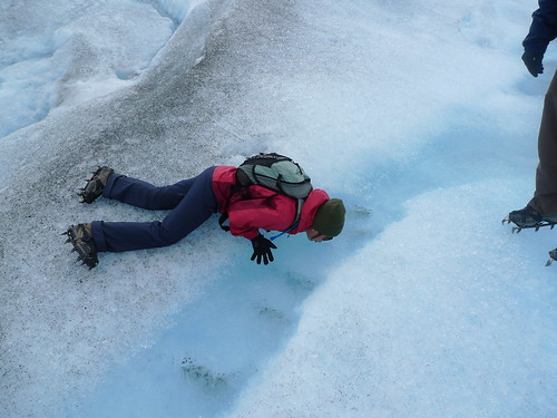
Day 4: Trekking on Glacier Perito Moreno

We took the bus back to El Calafate yesterday and said our good-byes to Monte Fitz Roy (Fitzie), Cerro Torre and the whole of El Chalten. Being in a bigger and busier town has its pluses, but walking along the main drag with all the amenities brought me closer to home and reminded me that we’re halfway through our two-week vacation. For the first time in almost a week though, we finally saw the sun set. Here in Patagonia, the sun sets at around 11pm and we’ve missed the last few because we would be indoors, inebriated from too much red wine and comatose from the day’s hike. (Cue in song, With a Little Help From My Friends…)

I fall in and out of sleep while on the bus to Perito Moreno Glacier, only to wake up with the same view around me: big mountain in front, water on the left, forest on the right; but no ice. It’s been more than an hour and I just can’t wait to get out of the bus and stand up. At the park’s entrance, a guide goes around with a small ticket machine charging us $60 Argentinian (about US$20) to enter. A few on the bus only had to say, Nacional, and they get a citizen’s discount at $20 Argentinian. This is the first time my group is charged for any sort of activity in Patagonia and all eyes are on me to make sure the fee is worth it.

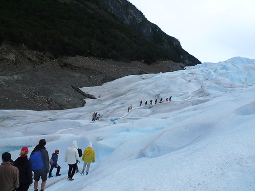
Back in New York, I’ve signed everybody up to do a mini-trek on Perito Moreno instead of just a bus ride to view the giant glacier from the balcony. It cost each of us US$100, which we all consider steep since we’re not the kind of travelers who pay for organized tour groups. But there is no such thing as shopping for a tour guide to do the mini-trek. Hielo Adventura has the monopoly to ferry tourists across the lake, suit them up with crampons and lead them on the glacier for an hour and a half before sending them back to their hotels. I later appreciate this because I couldn’t imagine hoards of people on the glacier trekking everywhere if one outfit didn’t control the number of visits to the top.

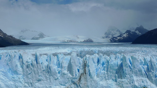
So what is a glacier? It’s technically a big mass of ice with two zones: accumulation and percolation. It’s constantly snowing in the accumulation zone while the ice is melting in the percolation zone. The ice moves down the slope from where they are situated and ends in lakes or cliffs and forms terminal moraines, or stones and dirt pushed by the glacier.

Named after the Argentinian explorer Francisco Pascacio Moreno, the glacier is popular because it’s one of the few that can be accessed as simply and easily as this. While most glaciers are in very high altitudes and extreme temperatures, Perito Moreno is only 50 miles from El Calafate and only 279 feet above sea level. Since 1917, the glacier has been stable: its surface, width and length have remained the same because the snow increase in the accumulation zone is enough to compensate for whatever’s melting in the percolation zone. Moreno acted as the expert–that’s why he was called perito–when the Patagonian border was being disputed between Argentina and Chile and donated the land for the first Argentinian National Park, but he never saw the glacier that was named after him.

We spend about twenty minutes ooh- and aah-ing at the glacier. It really is amazing how massive and far out it goes. The wind is steady and it’s warm enough to stay at the balcony with cameras in hand, waiting for a small piece to crack and fall into the river. (It’s probably one of the few places where you can hear people beg for the glacier to start cracking.) Whenever there is a crack–and it happens every few minutes–there is a thunderous noise, followed by a loud snap, like a gunshot, when the ice falls into the river. No matter how small, the fallen ice creates a ripple and another loud whoosh occurs. Everyone is on high alert when this happens because they want to capture the action on film, but most of the time, the crack happens somewhere we can’t see. There is always a cheer from people who catch the exact moment and it’s funny how automatic the reaction from the crowd gets after a few minutes.

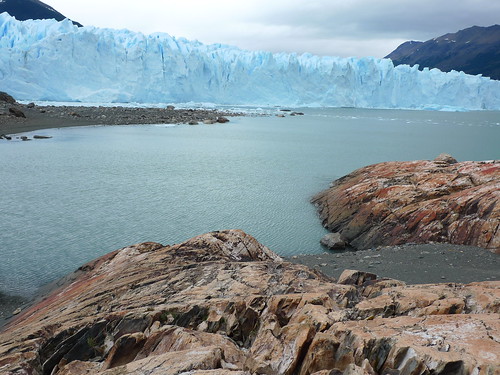
Two hours later, we board the bus to the pier and then the ferry across Rico Arm. From the boat, we can see the glacier’s front walls and some iceberg channels. Everything is of that blue-ice color. (Oh, why? Snow and ice is white, but when sunlight goes through a glacier’s solid ice crystals, it gets broken down into different colors. Blue light has enough extra energy to get away from the crystals without getting absorbed by the thick ice, so we see that blue that “escapes”.)

On the other side, we hike through a forest and see the contrast of the earth against the blue ice. It’s like walking into some kind of video game: dry land here, water in the middle, ice over there. All you have to do is hop over and you’re in a completely different landscape. One of the guides, after hearing that I’m from New York City, tells me that one of the most important movies shot in the city is also his favorite movie of all-time: Madagascar. I laugh, join in the joke and tell him that the penguins are probably still up to no good. The Dr. remains stoic because he never saw the movie. We put our crampons on.

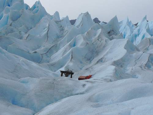
We see several groups of twenty ahead of us. The guides smartly separate all of us in a timely manner so that we all enjoy the glacier at our own group time. It’s never crowded while we trek and we never come across the other folks. We trek in one line and follow our guide, hunching forward when walking and leaning back when descending. I love the sound of crushing ice and I over-react and march with my knees up to get more of it. I take photos after photos of cracks and crevices and of small pools and trickles. I can’t get enough of the view. Ahead of me, the ripples of ice look like a meringue. It’s like some giant hand came down and whipped the ice to make soft peaks, you know? I know that sounds really gay, but it’s just that everything looked saaawft.

We stop where we drank from the small pond that has formed on the ice. The water is naturally cold and refreshing, but we still manage to convince ourselves that it is the best-tasting water we’ve ever had. For only US$100!

I jump when the guide isn’t looking and we do ridiculous poses when we get a chance to stop. They take us to small caves and let us peek down dangerous crevices. We walk across thin ice, jump over safe indentations and hike up and down small hills to get a feel of the massiveness of Perito Moreno. We end at a table where our guide chips off glacial ice to drink with the Famous Grouse whisky they’ve set up beforehand. Everyone toasts and munches on the dulce de leche candies they distribute. It’s the perfect end to our day.

Later, the group tells me that the money they paid was all worth it.

Related post/s:
Perito Moreno Glacier photos on Flickr
Day 3: Hiking to Cerro Torre
Hielo Adventura
Reflecting on Tikal, Guatemala

Jesus Antonio told me to look down and walk slowly right behind him. We were on Central Acropolis in Tikal and my guide was getting ready to show me his biggest surprise yet. Now, look up. I raised my head and was immediately in awe.

We’ve been walking through Tikal National Park and we’ve seen Complex Q and Group G. I was already impressed, but nothing prepared me to the sight of the Great Plaza from the top of Central Acropolis. Temple 1, also known as the Temple of Ah Cacao or Temple of the Great Jaguar, was on my right, Temple 2, or the Moon Temple, on my left. Right in front of me were structures I’ve only seen in books and magazines. Antonio showed us a dated postcard of Temple 1 to show how it looked before most of the excavations began–how amazing would it have been to follow the reports about a few protruding bricks, and then digging and discovering that they were at least 60 meters deep (that’s 200 feet up if you work from the bottom) and as old as the 4th century. And imagine that only a fraction have been excavated after decades of archaeological work!

Everything was covered by brush and trees then, except for the tops of the towers because vertical structures did not support the local plant growth. Tikal is so different from Mexico’s Teotihuacan, where there is no tree in sight to shade you from the sun. From Tikal’s Temple 4 and Temple 5, we sat on the platforms and saw the tops of the other buildings, as if floating among green clouds.

I climbed around Temple 1 and 2 to take photos of well-preserved stairs and view the excavated masks. The entire site had been estimated at 23 square miles. Now a UNESCO World Heritage Site, this largest of the ancient ruined cities of the Mayan civilization protected 100,000 to 200,000 people. It gave me goose bumps when I was there, and it’s giving me goose bumps as I write this now.

The Lost World, Mundo Perdido, was equally stunning, with its three-stairway pyramid now off-limits to traffic.

We saw coatimundis roaming around digging for food as we walked through the causeway in the forest. Howler and spider monkeys played with each other on tops of tall trees. A couple of toucan birds sat above us as we ate a La Lancha-prepared lunch of chicken sandwich, fruits and chips and salsa outside the visitors’ center with a cold bottle of Gallo beer I requested before we left the hotel.

I remembered that it’s Thanksgiving Day back in New York City. I know I have so much to thank for–being at Tikal, being in Guatemala, being able to travel on my own.

Related post/s:
Tikal National Park photos on Flickr
Ixpanpajul Skyway Bridge photos on Flickr
Biking and hiking in Cerro Cahui, Guatemala

Alone with My Thoughts in La Lancha, Peten, Guatemala

The sound started off as a deep howl. I knew it was coming from the howler monkeys because I’ve heard the same haunting sound before in other parts of Central America and in the jungles of Palawan in the Philippines. I’ve even had to dodge shit thrown by a family of them in Nicaragua! It was the Darth Vader-like hiss that made me go outside my room to get closer to the source. If you don’t know what it’s like, imagine standing next to a jumbo jet taking off without wearing any headphones. As far as I can tell, it was only early afternoon–I swore off checking the time the moment I checked-in–so I was mesmerized by how long the monkeys made their noise. I realized I’ve never heard them this loud and this close before.

I look around me and I see an inviting hammock. If I look past the trees, I can see a lake, the Lake Peten Itza of Guatemala. I’ve just checked in La Lancha, one of Francis Ford Coppola’s three resorts in Central America. Alone. I’ve planned four nights here, including Thanksgiving, to spend time by myself, collect my thoughts and just be at peace. I’ll try not to play too much Cat Power–there is an iPod speaker in my room; how brilliant!–and enjoy my time alone with the bottle of Crianza I brought with me.

My flight landed at 7:30am local time after a quick connection from Guatemala City to Flores. Funnily enough, I didn’t go through Customs before I made my connection. With this trip, I am completing Central America, but I won’t have that stamp on my passport. But I also swore off worrying about trivial things as soon as I got on a cab to the airport. I did get a little nervous when the security dogs were placed on the conveyor belt to sniff all the luggages that came through, but as soon as my backpack cleared, I waved at Henry, the La Lancha driver who was holding a piece of paper with my name on it. I was on my way to my small bit of paradise.

We drove the 45-minute journey to the resort. I was groggy from lack of comfortable sleep on the plane. Looking out the mini-van window, my first reaction was: how green! My surroundings was so lush. Past the tall trees, a thin sheet of fog covered the hills. When we finally reached the first town, I had my first glimpse of the lake. We continued to drive along its side, on rocky road, until we reached La Lancha.

The staff knew I was going to be alone and it showed. Ernesto welcomed me as “Miss Cia”–I got used to it easily–and showed me my room. You’ve come to the right place, Miss Cia, if you wanted to relax, reminding me of my first email request to book a cottage a couple of weeks ago. My room smells of fragrant soap, and the slow movement of the ceiling fan seems to dance with how I am feeling: it’s quiet, and inside, I feel completely relaxed, even subdued.

From outside my cottage, steep steps lead down to the lake. As soon as I changed to an outfit more appropriate for the 80-degree weather, I walked down until I reached the water. The lounge chairs were wet because it had been raining on and off for the past few days. There was a smaller chair that was dry, so I used that to drift in and out of sleep the rest of the afternoon. When I woke up and started to feel the pangs of hunger, I walked back up to my cottage and to the restaurant.

Carlos served me a bowl of hot carrot soup and homemade tortillas with spicy longaniza. Both filled me quickly, but I had watermelon juice with rum to push everything down. I spent the rest of the afternoon reading by the pool and then napping on the hammock. It’s raining now and it’s quite peaceful to hear water pelt on leaves; an occasional lizard tsk-tsks to remind me that I’m far away from any concrete at this moment.

I am that type of person who reads a travel-related article, looks it up online and bookmarks the results for just-in-cases. When I was planning my getaway, I looked through numerous Web sites I’ve saved to help me decide where to go. I was going alone, and I figured, I should at least check one thing off my list while I’m at it. With this trip, I consider Central America completely crossed off that list, and oh, “travel alone” accomplished, too.

Related post/s:
La Lancha Resort photos on Flickr

Fljotsdalur to Vik to Skaftafell, Iceland

We said good-bye to Fljotsadalur to start our drive towards Vik, our next destination for the night. On the way there, we stopped by Skogafoss, a pretty waterfall right behind another hostel that was still closed for the season. It was pretty huge but it wasn’t as deafening and impressive as Gulfoss. After checking in the hostel and eating lunch, we walked to the black sand beach of Reynisdrangur. They are tall fingers of black rock jutting out from the sea. The crashing waves contribute to the pure Gothic scene–all I needed was some Bjork music in the background. If the water wasn’t cold and the wind wasn’t blowing, it would have been the perfect beach with a view.

We still had a whole day ahead of us, so we drove all the way to the border of the southeast. We ended our drive at Svinafellsjokull just enough to get a glimpse of Vatnajokull. The travelers we met had two to three weeks of holiday and they were going around the entire country. The rest of Iceland will just have to wait until we return.

Our first stop was Lanfskalavaroa, this haunting open area of rocks on top of each other. You know when you hike and come across a pile of rocks that were left by other hikers to show you the right way? This was the mother of all those piles of rocks. It’s a tradition to put a rock on top of any of the piles before you continue your way so the Dr. and I put our own rocks on top of a pile before continuing down the road.

The scenery began to change as we approached the southeast. The moss-covered lava created by eruptions from the Laki volcano that lasted for ten months and wiped off several communities around it began to look green. We entered the southeast through the town of Kirkjubaejarklaustur and stopped by Foss, a thin waterfall right on a beautiful farm. It was like entering a fairy tale: the sun was shining, the flowers were blooming and then the waterfall ahead of us was quietly trickling. Iceland is a completely different country when the sun is shining.

Down the road were the basalt columns of Dverghamrar, also known as the Cliffs of the Dwarfs. They reminded me of Giant’s Causeway in Ireland with their hexagonal shapes naturally formed overtime.

Right at the base of the Lomagnupur cliff, we found the 18th-century church of Nupsstadur in an abandoned village frozen by time. If Foss was like a fairy tale, this was like the set of an old movie. I felt like someone was going to appear out of nowhere. The church door was unlocked. We walked in and there was a small altar with a photo of the Sacred Heart.

We continued driving along Skeidararsandur, the biggest of the southern sandurs, or wasteland of black sand and glacial debris from volcanic eruptions under the the largest icecap in the country, Vatnajokull. Before the Ring Road was built, the only way here was by horseback.

Before heading back to Vik, we found out that Dyrholaey was inaccessible because of nesting season. Another two weeks and we would have seen the country’s national bird, the puffin, all over the rocks and the beach. At least we were able to see the stone arch from Hallsanef Hellir. The caves also had the basalt columns but also sharp black edges that looked brittle and thin from afar.

About an hour and a speeding ticket from the Icelandic police later, we were back in Vik, reunited with the two Germans and playing Monopoly over some wine, rum and vodka. The Dr. whipped up some pasta dish to remake the leftover chicken from the night before as we finished the last bottle of wine from my suitcase.

Related post/s:
Day 4 in Iceland: Fljotsdalur to Vik to Skaftafell photos on Flickr
Day 2 and 3: Laugarvatn to Fljotsdalur, Iceland
Day 1: Keflavik to Laugarvatn, Iceland
Video courtesy of Tripfilms.com