
Here’s the video of our road trip in South Iceland, courtesy of Trip Films.
Related post/s:
All posts about South Iceland
Video courtesy of Tripfilms.com
Things to do in Iceland
Here’s the video of our road trip in South Iceland, courtesy of Trip Films.
Related post/s:
All posts about South Iceland
Video courtesy of Tripfilms.com
On the road back to Reykjavik, we drove by a sign that said “glacier walk” right outside Solheimajokull. I casually asked the Dr. if he wanted to check it out. He shrugged and made a U-turn. We drove down a gravel path, parked our car and walked to the opening of a glacier. We thought the sign would tell us to keep out because it looked a little delicate, with ice melting and water dripping. When we got closer to the sign, it only warned us against falling ice. We turned on our video cameras and started shooting as we entered the dark ice cave. It was the coolest detour ever!

Inside was a running brook formed by the melting ice. It was a little eerie and scary because the glacier has been melting throughout the years. Deep inside me, I was hoping that the thing won’t collapse while we were inside. I got claustrophobic after a few minutes, so I walked out and climbed up. The surface of the glacier was spotty–volcanic sand from Katla peeking through the ice. I imagined it was all covered in ice hundreds of years ago, but alas, we were witnessing the effects of global warming.


We just kept driving towards Reykjavik, eager to check in the hostel and rest since the Dr. had been driving since 10:30am. On our way there, we decided to skip town and drive to the Blue Lagoon to avoid the weekend crowd. It was the second best detour of our trip. We paid the fee of what turned out to be $20 each and soaked in the lagoon with the other tourists. It felt good to be in a hot spring with the sun shining. There were wooden chests around the pool filled with volcanic clay. We imitated everyone else and put them on our faces like mud masks. In between soaks, we spent time inside the saunas.

After the novelty ran off though, it was just like being in a regular pool. We felt the gooey clay beneath our feet. I grabbed some with my hands but there was hair all over. Gah! It was time to get out! The best part was getting out of the hot water and running to the showers in the cold. I’ll refrain from describing the feeling of seeing a hundred naked women of all shapes and sizes in the locker room.
We were completely relaxed when we arrived in our hostel. We were ready to conquer Reykjavik.
Related post/s:
Day 5 in Iceland: Vik to Solheimajokull to Reykjanes Peninsula photos on Flickr
Day 4: Fljotsdalur to Vik to Skaftafell, Iceland
Day 2 and 3: Laugarvatn to Fljotsdalur, Iceland
Day 1: Keflavik to Laugarvatn, Iceland

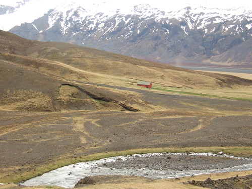
We said good-bye to Fljotsadalur to start our drive towards Vik, our next destination for the night. On the way there, we stopped by Skogafoss, a pretty waterfall right behind another hostel that was still closed for the season. It was pretty huge but it wasn’t as deafening and impressive as Gulfoss. After checking in the hostel and eating lunch, we walked to the black sand beach of Reynisdrangur. They are tall fingers of black rock jutting out from the sea. The crashing waves contribute to the pure Gothic scene–all I needed was some Bjork music in the background. If the water wasn’t cold and the wind wasn’t blowing, it would have been the perfect beach with a view.

We still had a whole day ahead of us, so we drove all the way to the border of the southeast. We ended our drive at Svinafellsjokull just enough to get a glimpse of Vatnajokull. The travelers we met had two to three weeks of holiday and they were going around the entire country. The rest of Iceland will just have to wait until we return.

Our first stop was Lanfskalavaroa, this haunting open area of rocks on top of each other. You know when you hike and come across a pile of rocks that were left by other hikers to show you the right way? This was the mother of all those piles of rocks. It’s a tradition to put a rock on top of any of the piles before you continue your way so the Dr. and I put our own rocks on top of a pile before continuing down the road.

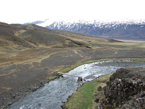
The scenery began to change as we approached the southeast. The moss-covered lava created by eruptions from the Laki volcano that lasted for ten months and wiped off several communities around it began to look green. We entered the southeast through the town of Kirkjubaejarklaustur and stopped by Foss, a thin waterfall right on a beautiful farm. It was like entering a fairy tale: the sun was shining, the flowers were blooming and then the waterfall ahead of us was quietly trickling. Iceland is a completely different country when the sun is shining.


Down the road were the basalt columns of Dverghamrar, also known as the Cliffs of the Dwarfs. They reminded me of Giant’s Causeway in Ireland with their hexagonal shapes naturally formed overtime.
Right at the base of the Lomagnupur cliff, we found the 18th-century church of Nupsstadur in an abandoned village frozen by time. If Foss was like a fairy tale, this was like the set of an old movie. I felt like someone was going to appear out of nowhere. The church door was unlocked. We walked in and there was a small altar with a photo of the Sacred Heart.
We continued driving along Skeidararsandur, the biggest of the southern sandurs, or wasteland of black sand and glacial debris from volcanic eruptions under the the largest icecap in the country, Vatnajokull. Before the Ring Road was built, the only way here was by horseback.
Before heading back to Vik, we found out that Dyrholaey was inaccessible because of nesting season. Another two weeks and we would have seen the country’s national bird, the puffin, all over the rocks and the beach. At least we were able to see the stone arch from Hallsanef Hellir. The caves also had the basalt columns but also sharp black edges that looked brittle and thin from afar.
About an hour and a speeding ticket from the Icelandic police later, we were back in Vik, reunited with the two Germans and playing Monopoly over some wine, rum and vodka. The Dr. whipped up some pasta dish to remake the leftover chicken from the night before as we finished the last bottle of wine from my suitcase.
Related post/s:
Day 4 in Iceland: Fljotsdalur to Vik to Skaftafell photos on Flickr
Day 2 and 3: Laugarvatn to Fljotsdalur, Iceland
Day 1: Keflavik to Laugarvatn, Iceland
Video courtesy of Tripfilms.com
The Dr. dreams a lot when we’re on vacation. As I tried to enjoy my morning sleep, the best type of all sleeps, he flinched and murmured with his eyes closed. I kept waking up because of him that by the time I felt like I’ve had a complete, uninterrupted sleep, it was already 1pm. Luckily, the sun does not start setting until about 11pm so we knew we had plenty of time.

We decided to go to Selfoss and get closer to the volcano Hekla since the road to Langjökull and Hofsjökull was closed. On our way to Selfoss, we saw a tour bus make a turn to Kerio. We followed it and parked our car. There wasn’t anything on the map but it turned out to be a beautiful crater full of water.
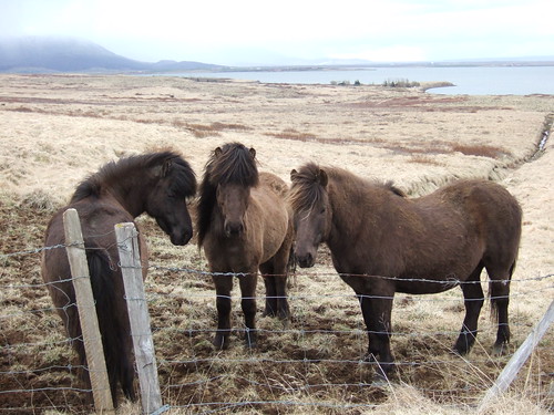
There was nothing in the town of Selfoss except a closed bakery (what, no fresh bread after 3pm?) and a library where we paid 100 kronas to use the Internet and email back home. We continued on for what seemed like miles and miles of dark earth to Mount Hekla. In medieval Europe, it was known as one of the twin mouths of hell because of how menacing it looked, hiding behind thick clouds. It is still active and the last eruption was in 2000. We stopped a couple of times to film the vast bleak view ahead of us. I found a few horses who were willing to cooperate, but otherwise, we didn’t really do much except drive.
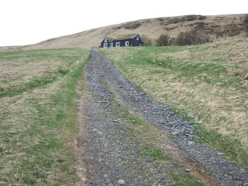
We made up for it the next day. We felt like we were finally, truly in Iceland. We started our drive early towards Fljotsdalur. There were few houses on the road past the town of Hella but it was a very scenic route. I remember thinking, I wish we can stay in one of those small barns with grass on the roof. To my delight, the Fljotsdalur was one of them!
We met Paul, one of the founders of the house with the infamous Dick Philipps of England. He’s been coming to Iceland for the summer the last 30 years. They do group hiking tours to þorsmork, or Thor’s forest. You can go there from hostel to hostel and cross the path between two icecaps, Eyjafjallajokull and Myrdalsjokull, but alas, we had to stay loyal to our tiny car which could only do so much. We only had a night so we decided to spend the rest of the day walking around the area.
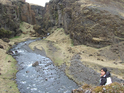
We walked up to the gorge and crossed a sheep farm to get closer photographs of Eyjafjallajokull. We crossed a bridge to go over a raging river and get on the other side. It felt like we were the only two people in the world. We walked for about three hours, taking photographs, shooting videos. It got cold when the clouds moved in. The sheep started walking back to the farm. We knew it was time to head back.
When we returned to the hostel, we met a Dutch couple and two Germans. It wouldn’t be a quiet night after all. The six of us all ended up chatting with Paul during dinner. The Dr. made a mean potato-cabbage salad with stewed chicken for our meal. (Everyone was amazed at how we simply could not subject ourselves to a simpler meal when hiking. They obviously don’t know us that well.) In exchange for some cooking oil, we gave Paul a glass of wine. In exchange for a Tupperware container to take leftovers with us, we served him a plate during dinner. It was a nice night of getting to know strangers in a new country.
Related post/s:
Day 2 and 3 in Iceland: Laugarvatn to Fljotsdalur photos on Flickr
Day 1: Keflavik to Laugarvatn, Iceland

We landed in Keflavik a quarter before seven in the morning. The line was long through customs. We had to go through X-ray again without our shoes and liquids since it was the point of entry to the rest of Europe for a lot of the passengers. Our luggage were waiting at baggage claim but we had to queue again to exchange our dollars to the local currency, krona. We picked up our light blue Honda Jazz from National with the pre-paid hostel vouchers I’ve reserved beforehand for the next six nights.
Driving outside of Reykjavik, my first impression was that the country was bleak and a little eerie. There were a lot of construction going on but the view was mostly a dry and flat valley as far as the eye can see. Our first stop was along a road marked Stardalur to take photos of the ice-capped mountains ahead of us. There would be more and better photo opportunities along the way but I was eager to start shooting.
We continued driving until we reached a spot with a tourist sign, the þingvellir, home of the þingvellir National Park set along the north of þingvallavatn, Iceland’s largest lake at 30 square miles. There was really nothing there except squishy bog covered with dry wildflowers and a view of the blue lake, but apparently, it is the only place in Iceland declared by law as sacred because it was also the spot where the country’s first settlers formed a commonwealth in the midst of Europe’s feudal monarchies.

The next stop was our home for the next two nights: Laugarvatn. It’s a small town with a golf course and a small spas but they were all closed because it was still off-peak season. The bonus, of course, was the Laugarvatn lake outside our room which made the water safe to drink from tap. I never thought I would ever say that water tastes so good. But it’s not a myth: Iceland has the best-tasting water. (Showering felt like I was wasting water; showering using what tasted and felt like bottled water!)
After settling in, we heated up some of the food we packed: Korean jjajang tuna and Japanese rice with some pickled perillo leaves. We knew food was going to be expensive and if we wanted to eat well the rest of the week, we had to pack easy-open cans and microwavable packets. For the next few dinners, the Dr. cooked hot meals using ingredients we bought in gas station stores along the way. We drank all four bottles of wine I packed.


Jet lag began to set in so we napped for a couple of hours. We woke up at 5pm local time, four hours ahead of New York, showered and made it to the town grocery store before it closed. We bought pasta and some sauce with the country’s infamous yogurt, or skyr. (I’m not a big fan of yogurt but I found myself eating a tub of it every morning because they taste so much better in Iceland.)
We started driving again on Route 35 and 37 to the Great Geysir which, sadly, hasn’t spouted since several tourists poured gravel into its mouth to lower the water level and force an explosion. The Strokkur was more reliable and we watched it spout boiling water every five minutes or so up to 66 feet. The entire area is still geothermically active and it was hard not to try and test the hot temperatures while the cold numbing wind blew on our faces. In fact, there are reported “accidents” each year from people who forget what scalding water really means.

We kept driving until we saw the sign for Gulfoss. Foss is “waterfall” in Icelandic and Gulfoss means “golden falls.” The road to the falls was barren and serene so it was an amazing sight to see the raging and deafening waters. Out of the calm was a welcomed chaos in a way. The river Hvita falls 105 feet into a mile-deep ravine and clouds of spray created rainbows.

Langjökull and Hofsjökull, two large ice caps, were ahead of us. Alas, the road was closed to cars until the F-road is dry and safe. This is known as the Kjölur route and could have been done in a day. We drove back to our hostel and thought we’d try the hot springs at the Laugarvatn lake instead but it was closed. The two restaurants next door were empty, too. We went back to our room dejected but we ended up cooking and playing Scrabble until the sun partially set at midnight (!).
Not so bad for our first day in Iceland.
Related post/s:
Day 1 in Iceland: Keflavik to Laugarvatn photos on Flickr